The Paintings of James McNeill Whistler
M.0029
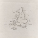
Map of England and Wales
Date
Map of England and Wales is signed and dated 1850, and was probably drawn when Whistler was at Christ Church School, Pomfret, CT.
Map of England and Wales, New York Public Library
Louise Chandler Moulton (1835-1908) remembered that the maps drawn at Pomfret by Whistler 'were at once the pride and envy of all the rest of us – they were so perfect, so delicate, so exquisite in workmanship.' 1
Images
Map of England and Wales, New York Public Library
Subject
Site
Map of England and Wales, New York Public Library
The map shows England and Wales, the Isle of Man, Channel Islands and Scilly Isles, but not Scotland. It includes Calais and a corner of the French coast at lower right. The English Channel is marked south of Cornwall.
Technique
Technique
Pink and brown ink were used for the map, sepia for lettering and dark brown for the signature. The thin paper was folded once vertically and twice horizontally.
History
Provenance
- 1850: given to Whistler's aunt, Catherine Jane Palmer (1812-1877), or her step-daughter, Emma Woodbridge Palmer (1835-1912), Stonington, CT;
- By or in 1912: given or bequeathed to Mary Anna Palmer (Mrs Henry Draper) (1839-1914);
- 1913: given by Mary Anna Draper to New York Public Library on 2 January 1913.
Emma Palmer showed the map to Charles Lang Freer (1856-1919), who described it as a 'beautiful little map of England', but returned it on 27 June 1904. 2
The provenance in MacDonald 1995 (cat. rais.) [more] (cat. no. 29) has been amended.
Bibliography
Catalogues Raisonnés
- MacDonald, Margaret F., James McNeill Whistler. Drawings, Pastels and Watercolours. A Catalogue Raisonné, New Haven and London, 1995 (cat. no. 29) as 'Map of England and Wales'.
Books on Whistler
- Pennell, Elizabeth Robins, and Joseph Pennell, The Life of James McNeill Whistler, 2 vols, London and Philadelphia, 1908, vol. 1, p. 28.
Notes:
1: Pennell 1908 [more], vol. 1, p. 28.
2: Freer Gallery Archives.